
Why National Geographic Denies Territorial Integrity of Ukraine
On February 24, 2022, the day when Russian missiles targeted Ukrainian cities, the website of the world-famous media National Geographic published an article about the beginning of "the special operation" entitled "Photos show chaos as Russia invades Ukraine." The iconic global brand, which is perceived by many as a leading expert on geography and maps, illustrates its material with such a map on this historic day of the full-scale attack on one country by another.
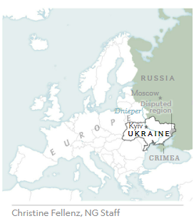
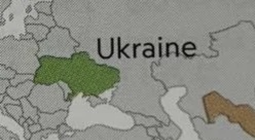
As we can see, National Geographic uses a map where Crimea has already "become" part of Russia. The east of Ukraine captured by Russian militants in 2014 under the legend of the "rebellion" is marked with the words "Disputed region." In the same publication, National Geographic uses a photo of Russian servicemen sent from Crimea to the war with the caption: “Conscripts for the Russian Army board a train after a send-off ceremony at the Sevastopol railway station in Crimea,” with no mention that in 2014, Russia occupied Crimea.
On that Thursday in February 2022, Ukrainians, apparently, did not protest against these errors because they had other worries.
Russian "dominions" and Ukrainian "claims"
Mykola Holubei, founder of the Stop Mapaganda! Information Deoccupation of Ukraine project, has been investigating the origin of propaganda cartographic images, disinformation, and the promotion of the idea of dismembering Ukraine in the educational products of the European Union, the United Kingdom, and the United States for several months. He pays special attention to how Ukraine is portrayed and described in educational materials because this is what forms the idea of Ukraine among European and American consumers.
In 2014 and now, Ukrainians have been confident that Russians will never be able to secure Crimea because the world will never recognize the theft. Ukraine has begun to counteract the spread of distorted maps. The Ukrainian Geographical Society urged foreign colleagues not to engage in legitimizing the Russian annexation. The Ministry of Foreign Affairs also started working in this field, communicating with publishers and the media, each year forcing them to correct dozens of disinformative cartographic images.
Despite all this, the National Geographic website publishes a map of 2019, on which Crimea is depicted as part of Russia.
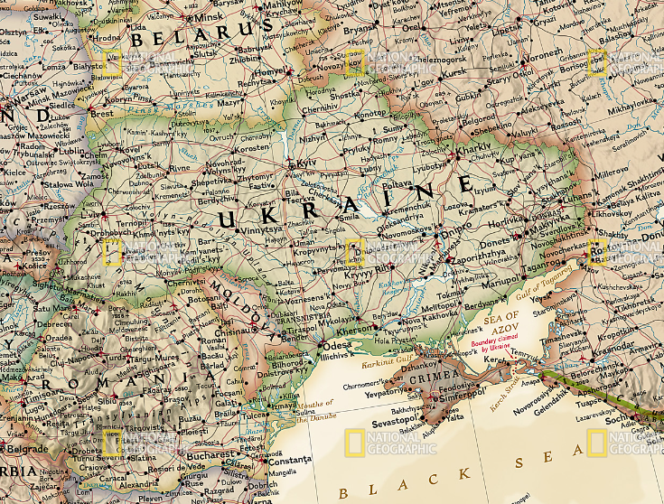
The only hint of the stance on this issue of the official Kyiv and the absolute majority of the global community is the almost visible line with the comment: "Boundary claimed by Ukraine." That is, it turns out that Ukraine is already portrayed as an aggressor who "claims" the territory of Russia. It is very consistent with the statement of Russian propaganda: "Russia has never attacked anyone! We are always only defending our territory."
Instead of taking the side of legality and justice, National Geographic "gives" Crimea to Russia and imitates "objectivity" with a mark that does not explain anything, except that Ukraine is dissatisfied with something in the Kerch Strait.
This map can be found in the Reference Maps section, which is recommended by National Geographic to other specialists. That is, these maps are created to be used by other publishers as a reference or template for developing new ones. It has the following description: "Expertly researched and designed, National Geographic’s Europe Wall Map is the authoritative map of Europe by which other reference maps are measured."
Many cartographic companies do follow this approach. Mykola Holubei emphasizes that this is only the tip of the iceberg. Now, for example, in Germany, Austria, and Switzerland (countries where he monitors cartographic products), it is becoming a difficult task to purchase educational materials with a correct image of the borders of Ukraine.
"I have collected materials about more than 30 international companies, as well as National Geographic, which develop, print, and massively distribute fakes and disinformation about Ukraine in educational products, electronic map services, and other educational resources of the EU, the UK, and the USA. These publishers effectively deny the territorial integrity of Ukraine. However, there is another aspect. How does such misleading affect EU consumers? Education is what shapes people’s profound understanding of the world. If education contains disinformation, then people will search for exactly the news that confirms their ‘knowledge’ of the world and become a victim of propaganda. We also need to protect Ukrainian children studying in Europe who may face such distorted maps," the activist believes.
 in Italian.")
 in Italian.")

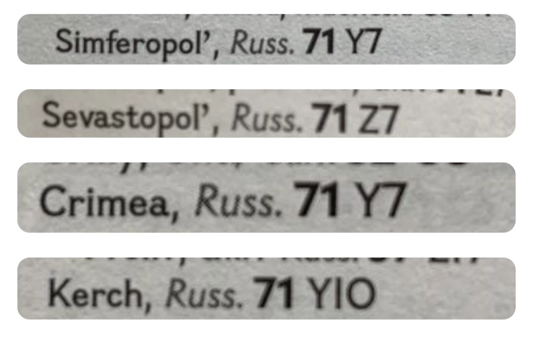
Weltatlas National Geographic Kids states that the Crimean cities are part of Russia in the index of geographical names at the end of the Atlas.
A year after the start of the war in Ukraine, on March 16, National Geographic decided to publish an article about the "greatness" of Russia: "How Catherine really became ‘The Great.’ Once the upstart foreigner stole Russia’s throne, there was no stopping her enlightened reforms, her empire’s expansion, and her pursuit of love and legacy." We will not ask about the motives for such interest in Russian imperialism at a time of unprecedented war, which Russia is conducting under imperialist and anti-Western slogans. Let us dwell on the fact that this PR material also contains a conscious act of cartographic aggression.
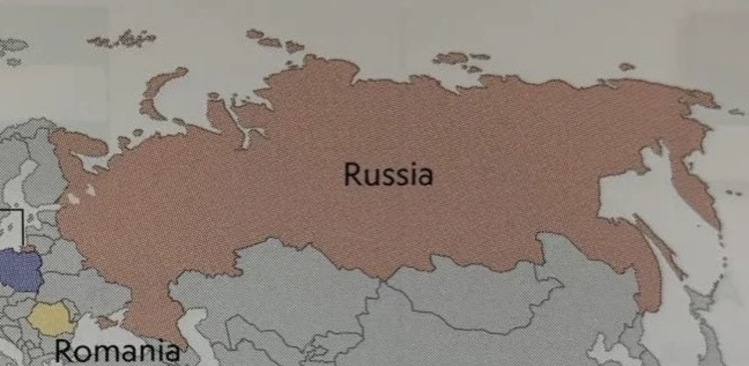
On the map, Russia-occupied Abkhazia and the Tskhinvali region are highlighted with dotted lines, but still remain within the borders of Georgia (Transnistria is similarly marked in Moldova). Instead, Crimea, occupied by Russia, is, for some reason, separated from Ukraine (but not from Russia) by the yellow line of the state border.
At the same time, National Geographic produces different versions of Ukrainian borders. In some, Crimea is within Ukraine, in others it is part of Russia.
Unfair marketing
The behaviour of a business that works with this kind of cartographic products may indicate that they are at least aware of the problem. But they overcome it in a very peculiar way.

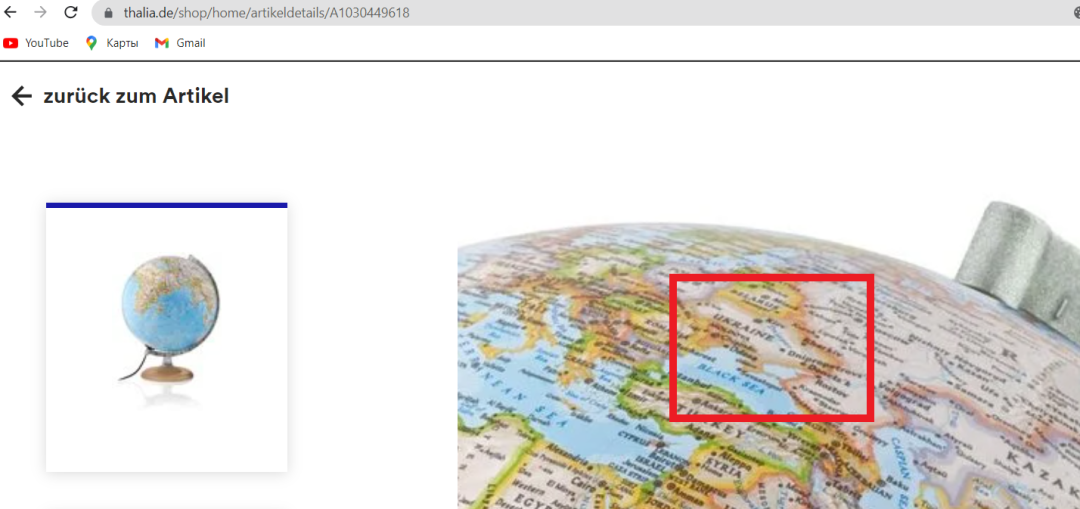
This fragment of the Silver Classic globe from National Geographic, acquired in 2023, also depicts Crimea as not part of Ukraine.
However, the advertising material on the Thalia store website, in which the globe was purchased, uses an illustration with the correct borders of Ukraine.
The Stop Mapaganda! volunteer team has collected a number of examples of direct deception of consumers, when the advertising and real appearance of products are significantly different.
There are cases when the same ISBN (International Standard Book Number) is assigned to different product samples, which portray the borders in relation to Crimea differently.
Unprincipled principles
In January 2023, the head of the International Cooperation Department of the State Geocadastre of Ukraine, Alina Sushchyk, appealed to National Geographic to correct its maps. Almost three months later, in April, she received a response from Mr. Scott, who referredto Alex Tait, responsible for map policy: "National Geographic maps reflect our policy of depicting de facto geographical situations, in accordance with our opinion. This policy is in line with our more than 130-year statutory purpose as a non-profit scientific and educational organization. Based on our policy, we indicate on our reference maps that Crimea is a disputed territory that is now controlled by Russia…"
For some reason, Mr. Tait says that Crimea, which is the territory of Ukraine, is not illegally annexed, but a disputed territory. However, National Geographic often depicts the peninsula not as a "disputed territory," but as part of Russia. At the same time, they do not do the same when it comes to other territories occupied by Russia — both in Ukraine and abroad.
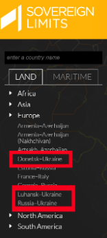
Mykola Holubei noted that Alex Tait, who has been with National Geographic since 2016, was previously a vice president at International Mapping, a company he mentions on his LinkedIn profile. This company presents the product Sovereign Limits; on its maps, it also separates Crimea from Ukraine. The company produces specialized maps of “disputed borders”: "Ukraine-Russia," "Ukraine-Donetsk," and "Ukraine-Luhansk."
In the description, the company repeats the Russian narrative about the "civil war" in Ukraine even after the full-scale aggression of Russia in 2022, and calls the occupied territories in the Donbas states: "From 2014 to the present, Ukraine has been involved in a military conflict with its eastern oblasts of Donetsk and Luhansk, collectively referred to as the Donbas region. The two States, which have Russian-speaking majorities, declared independence from Ukraine in 2014 after the Russian annexation of Crimea. While Donetsk and Luhansk received no official international recognition, they were supported militarily by Russia."

International Mapping in Sovereign Limits produces maps of the war-torn Ukraine with references to the "constitutions" of the so-called "DPR" and "LPR."
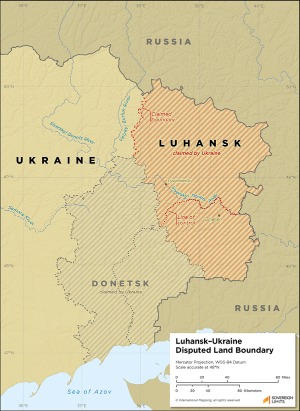
In addition to the maps themselves, Sovereign Limits issues extensive comments with the legal justification of such borders. The Stop Mapaganda! project team purchased maps with relevant explanations, which can be found at: Russia–Ukraine, Donetsk–Ukraine, and Luhansk–Ukraine. The last update of the document was in March 2023, after the illegal annexation of several regions of Ukraine, including the territories of the so-called "people’s republics," whose "constitutions" are referred to by Sovereign Limits.
National Geographic also has an official explanation of its own policy. It has not been updated since August 2022:
"National Geographic’s maps incorporate our policy of depicting de facto geographic situations to the best of our judgment. By de facto we mean states of affairs existing in fact or in reality, although perhaps not official, legal, or accepted. This policy aligns with our chartered purpose since 1888 as a non-profit scientific and educational organization. International boundaries and territorial control as shown on our maps reflect de facto status at the time of publication. […] National Geographic strives to be apolitical, to consult multiple authoritative sources, and to make independent decisions based on extensive research."
Cooperation with Russia
"In 2009, after Russia’s war against Georgia, a new page begins in the history of the Russian Geographical Society (RGT),” says Mykola Holubei. On November 19, an extraordinary congress of the society is held, and the Supervisory Board is headed by Vladimir Putin himself. Among the members of the Board are Russian and foreign philanthropists. Sergei Shoigu is elected President of the RGT. Therefore, the Ministry of Defence of Russia becomes the key ‘partner’ of the RGT."
The Russian Geographical Society immediately started taking charge of the territories of Ukraine occupied during the full-scale invasion. Here is, for example, a news story from the RGT website dated October 7, 2022: "Crimean geographers are establishing contacts with new territories of Russia." It was about Kherson, which was "forever with Russia" until the invaders were expelled.

"Geographers" from the Russian Geographical Society in occupied Kherson.
On November 1, 2015, National Geographic signs a "Memorandum of Understanding" with RGT. According to National Geographic Vice President Terry Garcia, cooperation with the Russian Geographical Society is one of the priority areas for the American side, which is greatly facilitated by the existing experience of interaction with Russian colleagues in media and expedition projects.
The occupation of Crimea, the war unleashed by Russian militants in the east of Ukraine, the Malaysian Airlines Boeing shot down by them — none of this was a warning to American partners from National Geographic. In October 2018, the RGT and National Geographic extended the cooperation agreement.

How to counter cartographic propaganda?
Distorted maps are produced not only by National Geographic, but also by a number of other leading publishers. What should Ukraine do to solve this problem? On June 14, 2023, a round table "Territorial Integrity vs. Cartographic Propaganda" was held, organized by the Centre for Strategic Communication and Information Security and the Ukrainian Geographical Society.
During the discussion of the problem, Iryna Borovets, Director of the Department of Public Diplomacy and Communication of the Ministry of Foreign Affairs, said that counteraction to disinformation on maps began immediately after the hybrid attack of Russia. In 2015, the Ministry implemented the #CrimeaMap #CrimeaIsUkraine project, in which the Ministry of Foreign Affairs asked citizens to report cases of distorted maps. Then the embassies that responded to it were engaged.
“In half a year of 2023 alone, there were 20 such cases that the Ministry of Foreign Affairs corrected, last year — 25 cases. But it’s like fighting the heads of a dragon, when several new ones grow in place of the severed one. The easiest way is to correct the map in online media. It is more difficult with printed maps. However, there were also successful cases when, after the intervention of the embassy, printed products were removed; for example, in the UK, Oxford University Press seized the socio-economic atlas of the world for 2016, in France, the socio-economic atlas of the world for 2017 was removed," Iryna Borovets said.
However, the Ministry of Foreign Affairs does not communicate with governments that comply with international law and recognize the legitimate borders of Ukraine, but with business: publishing houses over which governments in democratic countries do not have direct influence. Business may respond: "our publishing house is apolitical, we rely on professional expert materials, this is our right." That is why it is necessary for Ukrainian diplomats to rely on the professional arguments of lawyers and geographers, and the problem must be brought to the level of international specialists discussions.
The Embassy of Ukraine in the United States has been negotiating with National Geographic, Google Maps, and Amazon for a long time.
In addition to speeches by experts, it is crucial that there be publicity. Citizens can hold public events against attempts to legalize crimes and territorial seizures on geographical maps. It is necessary to raise this issue in the Western media as well.
To consolidate these efforts, the first meeting of the Interagency Working Group was held on June 29 to develop mechanisms for disseminating information among foreign cartographic publishers, geographical and cartographic national and international organizations on the unity and territorial integrity of Ukraine within its internationally recognized border.
This working group, established under the StateGeoCadastre, included representatives of the Ministry of Foreign Affairs, the Ministry of Information Policy and Culture, the Centre for Strategic Communication and Information Security, the Ministry of Education and Science, the Representative Office of the President of Ukraine in the Autonomous Republic of Crimea, the National Security and Defense Council, the Ukrainian Geographical Society, as well as public activists of the Stop Mapaganda! project. Experts should develop mechanisms to respond to the situation when leading publishers produce maps, atlases, textbooks with distorted borders of Ukraine.
Viacheslav Oleshchenko, president of the Ukrainian Geographical Society, believes that after expert consideration, the issue should be brought to the highest level. The situation will also be improved by direct communication of Ukrainian geographers with their foreign colleagues. But it is necessary that Ukraine’s position be reasoned and clearly explained. It is necessary to turn not only to practitioners, but also to scientists, so that they provide their expertise.
"Despite all the freedom of business in any country, there is its own legislation that companies must comply with," says Viacheslav Oleshchenko. Together with lawyers, we are looking for arguments to show publishers that it will be more favourable for them to do what is right. It is unacceptable to condone the illegal actions of criminal regimes; this provokes wars. Frankly, I have already heard some of my foreign colleagues who are heads of professional international associations of geographers say that if these organizations had taken a more principled position on the image of Crimea immediately after Russia’s aggression in 2014, it would have reduced the chances of an attack in 2022."
Among other things, the working group heard proposals to introduce systematic monitoring of cartographic products in the countries of the world, as well as to establish production of maps in different languages with comments so that Ukrainian diplomats and activists could clearly show an example of correct and incorrect maps. Therefore, work on a systemic solution to the issue is underway.
"The flagship atlas of the National Geographic Atlas of the World 11th Edition at the end of the index states that Crimea is part of Russia. They write the same thing in the atlas of the world for children. This is for those who believe there is little evidence of disinformation on maps, Mykola Holubei provides another example. I believe this is a milestone. If we take this company — the most powerful and famous, and resort to certain legal actions regarding it, for example, the imposition of sanctions, this will be the best step because it will give a signal that we are past the stage of requests. I want to point out that all these companies are professional cartographic publishers, especially National Geographic. The people who work there are well aware of what they are doing. These people understand perfectly well what the norms of international law are and that they violate them. Since 2014, the Ministry of Foreign Affairs and various activists have been negotiating with these companies. The result is almost the same as the negotiations with Russia. These companies use negotiations as an opportunity to stall. I believe that Ukraine should be tough in repelling encroachment on its integrity, both on the battlefield and in the information plane."

According to the activist, it is necessary to demand that companies conduct internal investigations: who and how exactly adopted the decision to use maps with the Russian stance, and whether the Putin regime corrupted the relevant employee. "What are their apologies to us? These companies should compensate for the damage caused," Holubei is convinced. He adds that the damage can be calculated because the number of issued incorrect maps is recorded.


